


You're traveling on board Aamtrack's Superliner train-the California Zephyr, or the connecting Superliner that joins Zephyr in Salt Lake City-the Desert Wind. While on board, you'll be experiencing the utmost in train travel, and some of our country's most spectaaculr and well-known scenery; the Rockies and Sierra Nevadas; the snow-topped mountains, the exciting golden sunsets of the West; the desolating beauty of the desert in the Southwest.
Amtrak and your crew are proud to host you on board. We'll do everything we can to ensure you enjoy your trip. If you have any questions, please don't hesitate to ask your Attendant or On-Board Service Chief.
The California Zephyr and Desert Wind feature on-board activities the whole family will enjoy. Listen for annonuncements of the specific time and location of activities, and most of all-have fun!
Movies in the Sightseer Lounge Car are offered between Chicago and San Francisco; other videos including features for children are also shown during summer months.
Hospitality Hour. Join fellow passengers in the lounge car for drinks and complimentary snacks.
On-board Tour Guides from the California State Railroad Mueseum provide highlights year-round between Sacramento,Ca and Reno,NV.Beginning in June through Labor Day. Tour guides from the white river national forest service furnish their knowledge of the beautiful area from Glenwood Springs, CO to Denver, Co.
Games are usually conducted during the trip. Small prizes will be awarded. Listen for announcements for time and location.
Stretch your legs. The California Zephyr stops in Denver so the train can be serviced, refueled and washed. This is your opportunity to inspect souveneirs at the station. Please do not leave the station platform area, and return to the train as soon as the departure announcement is made.
The Conducter is in charge of all crew members and is responsible for the collection of tickets and the safe operation of the train. The Chief of On-Board Service supervises the on- board service crew, and oversees the quality of service.
Roomy Coach Seats. Your Coach attendant will see to the needs.Since your seat is assigned for the length of the journey, please do not change without first consulting a crew member.
Private Sleeping Compartments. Your Sleeping Car Attendant will prepare you for daytime or nighttime use, provide wake-up calls and bring the morning paper and the beverages. Individual speakers bring recorded music on Channels 2 or 3, and train announcements on Channels 1 and 2. Simply turn the channel selector near the reading light. First Class passengers receive complimentary meals in the Dining Car.
Economy, Family, Special and Deluxe bedrooms are available. Special bedrooms have a private bedroom and Deluxe bedrooms have private baths with shower. Sleeping accomodatios may be purchased on board from the Conductor if space permits.
Dining Car Service. The Dining Car features complete meals in a comfortable setting. Major credit cards are accepted. A crew member will contact you if dinner resrvations are necessary.
Spectacular Sightseer Lounge Car. Between Chicago and San Francisco, you can enjoy the magnificent scenary from the large picture windows from the Sightseer Lounge Car: and don't forget the sandwiches, snacks and beverages available for purchase at the Cafe Bar. You can also purchase souveneir playing cards, post cards and blankets. Lounge Car hours are generally from 6 a.m. to 12 midnight.
The California Zephyr and Desert Wind are smoke-free trains.
Scenic Spots: your train passes many beautiful and intresting sights. The "camera" symbol on your Route Guide Map marks the best spots, so have your camera ready!
Outside Shots: Medium speed films (ASA 64 or higher) are recommended for shooting scenery in the train windows. IF your shutter speed is adjustable and light conditions permit, set it at a higher speed (1/125 or 1/250 sec.) for the clearest results. Hold your lens close to the window to eliminate glare and reflections.
Inside Shots: Flas is recommended. To aavoid glare and reflections, do not point the flash directly at the windows.
Explore the beauty, romance and exciting history of the western frontier.
Amtrak's Superliner Service to Chicago offers a wide variety of ways to explore the beauty, romance and exciting history of the western frontier.
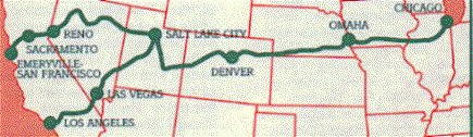
This guide outlines highlights of the scenary and historic landmarks along the route of the California Zephyr and the Desert Wind. Look for the heading with the name of your train. There will be a brief description of the route followed by the name of the city where the train orinates in the west.
The guide is written from west to east, noting how many minutes past the previous Amtrak station you can expect to see a particular sight and whether you should look right or left. The first time reference tells you how far that point is from the next Amtrak station to the west, and the second time, how far it is to the next Amtrak station to the east. If you're traveling westward, just begin at Chicago of Salt Lake City of your point of origin and read the entries in reverse order. Remember to look left when we,ve indicated to look right, and right when we've indicated to look left.
Note that all Amtrak Stations are in all capital letters to set them apart from towns and regions through which the California Zephyr travels but makes no stops. Use this guide along with an Amtrak timetable to determine station times. all times in this guide are approximate.
The discovery of gold in the California hills brought thousands of pioneers by land and sea to the golden city of San Francisco. Eventually, the route of the historic overland trek would include railroads, telegraph lines and way stations through the hostile unmapped territory. In 1869, the nation was linked by the first transcontinental railroad when the Golden Spike was driven at Promontory, Utah. These are some of the same lines which the California Zephyr follows today.
The cross-country journey includes the awesome challenge of crossing the Sierra Nevada Mountains and the Rocky Mountains. Many of the cities and towns in the wild west surivived boom and bust times because they were on the railroad lines that make up the route of the California Zephyr today. Sit back and enjoy the beauty of the world famous scenery along the California Zephyr route.
San Francisco Unmatched charm and character are the trademarks of this city. The unusual skyline is marked by ultramodem skyscrapers, the red-tiled roofs of Spanish architecture, the quaint Victorian homes of the Mission district and prrestigious residential areas of Telegrraph Hill, Nob Hill and Pacific Heights. Thsi cosmopolitan cultural center is the home of world famous restaurants, galleries and shops. San Francisco has the west coast "Wall Street", a financial district comprised of several of the world's largest banks. It has world class ballet, symphony and opera companies. Antrak passengers begin and end their journey to San Francisco with a bus ride across San Francisco Bay to or from the Oakland Train terminal.
San Francisco/Oakland Bay Bridge On the way to and from the Amtrak terminal in Oakland, passengers cross this bridge and Yerba Buena Island, passing the Treasure Island Naval Station. On the left is a spectacular view of San Francisco, the island of Alcatraz and, in the distance, the beautiful Golden Gate Bridge. On an Oakland side, the port of Oakland is on the right. The university of California at Berkeley's big Gothic clock tower, "Campanile" can be seen nestled on the hillside on the left.
Emeryville This is the terminus for Amtrak trains serving San Francisco. Shuttle buses to and from San Francisco are waiting for passengers at trainside. The train starts it journey on the tracks of the Southern Pacific Lines, which it follows as far east as Winnemucca, Nevada.
Richmond This station is the interchange with the Bay Area Rapid Transit (BART) system, offering connections to points throughout the region. BART trains can be seen on the right. Between Oakland and Richmond, look for the skyline of San Francisco and the Golden Gate Bridge on the left, across SAn Francisco Bay.
San Pablo Bay and the Carquinez Strait (5 Min./10 Min.) This large shipping lane and recreational waterway is also home of the Mare Island Shipyard, which can be seen across the water on the left side of the train. The California and Hawaaii (C&H) Sugar Plant is on the left track just after the Carquinez Bridge. Across the strait on the left of the bridge is the California Maritime Academy.
Martinez Don Ignacio Martinez was the Spanish governor of this area and his surname graces the town. To the south of Martinez is the home of John Muir, naturalist and conservaationist, who walked across most of America and convinced President Theodore Roosevelt that "wilderness is a necesssity," Benicia, to the left across the bridge, was the capital of the state from 1853 to 1854 before the statehouse ws moved to Sacramento. Here the train crosses the Carquinez Strait aas the mouth of the Suisun Bay on the Martinez-Benicia Bridge. To the right is a loading dock where 150,000 automobiles per year are unloaded from Japan.
Provo Utah's third largest city has an abundance of agricultural and mineral wealth. It is situated at the baase of "Y" mountain, part of the Wasatch Range. It is the home of the nation's largest private university, Briiggham Young University aand the Osmond Entertainment Center where Donnie and Marie Osmond taped their shows. Outside of Provo is the entrance to Uinta and Manti-La Sal National Forests. The train enters the Wasatch MOuntains and follows the river uup the Spanish Fork Canyon.
Thistle (26 Min./92 Min.)This tiny village on the Spanish Fork River was destroyed by a mudslide in April, 1983. Part of the original railroad line was also buried. Roofs and parts of houses can be seen on the right side of the train. The railroad's main route was blocked for three months until a six-mile bypass could be built, including a new 3,000-ft. tunnel through Billy's Mountain.
Soldier Summit (55 Min./50 Min.) The train curves back three times as it winds through a series of horseshoe curves and bends on the way to the summit of the Wasatch Range, 7,440 feet high. To the right is the final resting place of some of the Union soldiers in Johnson's Army, buried here in 1860. This area has a number of abandoned mine shafts such as the one on the right. Also on the right is Davidson Canyon, one of the prettiest in Utah. Once over the top of the summit, the train enters Price River Canyon.
Castle Gate (108 Min./10Min.)A rock formation in front of the train resembles a gigantic castle door that seems to open and close as the train enters and leaves the mountains. High up on the hill to the left is Balancing Rock with a makeshift flag. The mass of machinery on the left is a processing facility for coal.
Helper Additional "helper" locomotives are added to freight trains to help them over the mountains, giving this railroad town the name helper. Local coal is plentiful enough to supply the U.S. for 300 years.
Price (7 Min./93 Min.) It may be small, but Price is the largest town until the train reaches Grand Junction. The Book Cliffs on the left extend all the way to Colorado.Composed of sandstone and shale, they provide evidence that this whole valley was once under water.
Green River (70 Min./27 Min.) At 4,075 feetm this is the lowest altitude en route from Salt Lake City to Denver. The town is known for its cantaloupes and watermelons. The moountains to the right are Mt. Marvine, 11,600 feet, and Thousand Lake Mountain, 11,306 feet. This is also prime "jackalope" country. These hare-like, antlered creatures are legendary for their size and proliferation.
Thompson This desolate region, called the nation's atomic warehouse because it is rich in uranuim, is also the gateway to Canyonlands and Moab, the Arches National Park, Manti-La Sal National Forest, and Dead Horse Point. The eroding mesas on the left are the Book Cliffs.
Ruby Canyon (40 Min./18 Min.) At this point, the tracks begin to follow the route of the Colorado River for 238 miles. Enter the beautiful red rock formations of the Ruby Canyon, the eastern "gate" of the Utah desert. The canyon was formed by the Colorado River carving its way through the Uncompahgre Plateau. Waaterm wind and eons of time have hewn smooth textures of fascinating shapes in the striking res stone. The swift river and the elements continue to create new indentations in the canyon walls, etching a record of nature's events.
Utah/Colorado State Line The state line between Utah and Colorado is marked at Utaline by a sign painted by railroaders on the canyon wall to the left.
Grand Junction The Gunnison and Colorado Rivers meet here. Grand Junction is the gateway to Mesa Verde National Park, the Colorado National Monument and Grand Mesa National Forest, enclosing the city on each side with stately mountains. The fertile Fruita Loma Valley, where Grand Junction is located, is a major producer of fruits, vegetables and minerals.
De Beque-Palisade (39 Min./80 Min.)The huge mountain toward the east is the Grand Mesa, the world;s largest flat-top mountain. The De Beque Palisade area produces over three million bushels of fruit each year, including peaaches, pears, apricots, apples and cherries.
Grand Valley (50 Min./68 Min.)The Parachute Mountains, to the left, are named for the billowing parachute shapes that they suggest.
New Castle (90 Min./29 Min.)In 1896, an explosion at the nearby Vulcan mine killed 54 miners. The blast threw mine timbers 400 feet into the river. A secoond explosion in 1931 leveled the works, killing every man, a total of 37 fatalities. The mine is still on fire. Baxter Mountain 11,188 feet, is to the left.
Glenwood Springs Roaring Fork River meets the Colorado on the right. The infamous gun-slinger Doc Holliday is buried here. Glenwood Springs was also a favorite of Teddy Roosevelt, who stayed at the Coloradp Hotel and enjoyed the revitalizing waters of Yampa Hot Springs, now one of the laargest outdoor pools in the world. Other recreation in the area includes fishing, backpacking and skiing, with Aspen and Redstone resorts just a short drive away. White water rafters salute the train while riding the rapids on Colorado.
Glenwood Canyon (1 Min./150 Min.)Just outside of Glenwood Springs, the train enters Glenwood Canyon and the White River National Forest. The spectacular high cliffs are dotted with aspen and everygeen trees. The colorful jutting rocks form a myriad of unusual shapes.
Dotsero (45 Min./140 Min.)A survey of the Colorado River began at Dotsero in 1885. The survey team marked their maps with a ".O" ("dot-zero") at the junction of the Colorado and the Eagle Rivers and it has been called Dotsero ever since. This is also the approximate midpoint of the Zephyr's 2,427-mile journey.
The Red Canyon (60 Min./115 Min.)The Red Canyon has vivid and unusual rock formations, which helped inspire the Spanish to name this country and the river "Colorado"-red.
Gore Canyon (85 Min./40 Min.)The towering spires of the Gore Canyon have rock walls reaching 1,500 feet above the river. The lofty peaks to the right belong to the Gore Range and rreach elevations of over 13,000 feet. The train follows Gore Canyon for 22 miles, and much of the rugged canyon can be reached only by train.
Kremmling (140 Min./35 Min.)The town of Kremmling is to the left of the train. Vail, Colorado, is 70 miles away on the other side of beautiful Mt. Powell, 13,534 feet, to the right.
Byers Canyon (162 Min./16 Min.) An occasional buffalo can be seen among the cattle in this area. Byers Canyon is filled with unusual "pagoda" rock formations high aboce the tracks. The red and gold rocks have been shaped by waater and wind into an infinite array of delightful patterns.
Granby This station is the gateway to Rocky Mountain National Park. The vast meadowlands in this area make up a region called Middle Park. Evidence of Aboriginal people has been found at nearby Windy Gap Dam dated at 3000 B.C.-1200 A.D., predating modern Indians. Silver Creek ski area and Winter Park are across the valley to the right.
Fraser Canyon (5 Min./18 Min.) The train follows the Fraser River through this remote canyon.
Tabernash (15 Min./10 Min.) was named for a local Indian chief. It was also a station where "helper" engines were added for the long, steep climb over Rollins Pass prior to the boring of the Moffat Tunnel.
Winter Park (Fraser) This is the station for the nearby Winter Park Ski Resport. The clear and cold Fraser River cuts a swath through Arapahoe National Forest and Fraser Canyon. This was the favorite fishing spot for President Eisenhower, particularly the mountains on the right. The town of Fraser proudly calls itself the "Icebox of America" because of its winter temperatures of -50 F. The Devil's Thumb is a rock formation on top of the ridge to the left.
Winter Park Ski Resort (10 Min./105 Min.) Located at the western portal of the Moffat Tunnel, this ski area was built as part of Denver's mountain parks system. The slopes, to the right, come right up alongside the railroad.
Moffat Tunnel (10 Min./95 Min.) The train crosses the Continental Divide, at an altitude of 9,239 feet, under Rollins Pass, beside James Peak, 13,260 feet above sea level. On the east side, the old train tracks that crossed Rollins Pass can be seen above sea level. On the east side, the old train tracks that crossed Rollins Pass van be seen above. This route was called the "Giant's Ladder," which reaches the dizzying height of 11,600 ft. The journey around James Peak used to take more than 5 hours until the Moffat Tunnel was built,cutting the trabel time to just over 10 minutes. The tunnel, 6.2-miles long, took 5 years to construct, opening in 1928.
South Boulder Canyon (45 Min./50 Min.) This area is the location of the Roosevelt National Forest and the Gross Reservoir, with its 340-ft. high dam, which supplies Denver with fourteen billion gallons of water. Watch for deer and elk in this region. The train passes through 29 tunnels in this area, the shorest only 78 feet and the longest, the Moffat Tunnel, 6.2 miles long. The track grade is a steady 2% between here and Denver. A wooden flume on the far canyon wall, on the left, once sent logs to the Eldorado sawmill.
Plainview (95 Min./45 Min.) From this area at night, 1,500 feet above Denver, there is a spectacular view of the city. Day or night, it is possible to see the Rocky Flats nuclear arms. manufacturing plant, to the left, and the city of Boulder to the north. Beyone Denver to the east strech the Great Plains.
Coal Creek Canyon (100 Min./40 Min.)is to the right as the train passes over a small bridge. People still pan for gold in Central City, not too far from this canyon. The tracks can be seen far below as the train winds between the Front Range of the Rockies and Denver.
Rocky (105 Min./32 Min.) Railroad cars filled with sand protect freight trains from winds that occasionally reach 100 miles per hour at a point called "Big 10" Curve. As the train approaches Arvada, a Denver suburb straight ahead, note the tall peak to the right. This is Mt. Evans, at 14,264 feet.
Denver Denver's skyline is notched with an impressive array of modern buildings, many built by the energy industry. Historic Larimer Square is only a few blocks away from the trian station. The 24K gold-domed state capitol contains the entire world's supply of Colorado Onyx, and the 13 the step leading to the capitol is one mile high above sea level. Denver is nestled up against the foothills of the Rockies on the barren High Plains. This is a refueling and servicing stop for the train. Here, the Zephyr changes railroads: the Rio Grande Railroad is to the west, and to the east, the Burlington Northern exstends to Chicago.
Commerce City (20 Min./65 Min.) On the northeastern edge of Denver, the train passes through Commerce City. This industrial suburb of Denver has the nation's largest sheep market. It also has a number of sugar beet factories and cattle yards which line the tracks.
During the night the train stops at Ft. Morgan.
Note:at the Colorado/Nebraska State Line (45 Min./70 Min.) Change your watch between Mountain and Central, one hour later if going east, one hour earlier if going west.
During the night, the train stops at McCook, Holdrege and Hastings.
Lincoln The 400-ft., 14-story, ten million dollar state capitol building, the "Tower of the Plains," dominates this city, on the right. The golden dome has a statue at the top which is not of a University of Nebraska football coach, as many suggest, but the symbolic "Sower." The state fair grounds are to the left. The Univeristy of Nebraska campus and stadium are visible from the train, on the right, just east of the station.
Platte River Along the historic Platte River, the Mormons trabeled the north bank for several hundred miles in their quest for the holy land. The Pony Express and Oregon Trail followed its south bank.
Omaha was a Missouri River crossing for west-bound pioneers, Omaha has always been a large transportation center, supporting as Stockyards were established here in 1884. President Gerald Ford, Henry and Malcolm X were born here. Boys Town, a refuge for homeless and underprivileged boys is west of town.
Offutt Air Force Base (10 Min./90 Min.) The Strategic Air Command has its headquarters here at Offuet Air Force BAse, to the right of the train, as does the 55th Strategic Reconnaisance Wing, which conducts global reconnaisance mission. Offutt is the home to the National Airborne Command Post, used by the President in times of crisis (look for military versions of the Boeing 747 on the field). This is also the site of the SAC Museum. The train follows the Missouri, on the left.
Missouri River (25 Min./87 Min.) The magnificent Missouri River was called "mini-souri" by the Indians. Its headwaters are in Montana where the Gallatin, Jefferson and Madison Rivers come together. In the 1800s, steamboats plied the Missouri all the way form Omaha to St. Louis, wher it flows into Mississippi. Crossing the Missouri, the train also crosses between Nebraska and Iowa.
Stanton (64 Min./50 Min.) This homestead of Sedish sttlers was also the home of the famous TV coffee lady, Mrs. Olson. So, the town's water tower on the left, is in the shape of a coffee pot.
Creston The train crosses the summit of the ridge between the Des Moines and Missouri River Valleys, the highest point east of the Missouri on the Train's route. The town's depot is now a national landmark. The tall cement silos of the Farmers Cooperative on the left offer a ride to the tip for a bird's eye-view of Creston.
Osceola A carved wooden bust of the Seminole Chief, Osceola, can be seen to the right of the train just past 1-35, west of the station. Settlers in the 1800s found the first Delicious apple tree here, thirty miles to the north.
Ottumwa This town rises on terraces above the Des Moines River. It was the home of General Joseph M. Street. Indian agent, who built a trading post in 1838. It was built also the hometown of the ficiotnal character "Rader O'Reilly" from the television show MASH.
Mt. Pleasant The oldest college west of the Mississippi was established in 1842 as Iowa Wesleyan firstAmerican coed, Lucy Kilpatrick, graduated from there in 1859. The city had the first plank toll roads leading to Burlington in 1851. And the first Iowan courthouse was built here in 1839.
Danville (15 Min./15 Min.) was the site of a Pony Express and stage stop.
Burlington Flint in the nearby Shoquaquon Hills provided tools and weapons for the Indians, and they considered this area "neutral ground." Zebulon Pike established a fort here in 1805, and Abe Lincoln fought here as a captain in the Black Hawk Wars. Before the first Railroad bridge was built in 1868, passengers and freight crossed the Mississippi in ferry boats. In winter they had to brave the ice on foot. In 1887, George Westinghouse developed the air brake on West Burlington Hill.
Mississippi River (2 Min./45 Min.) The train crosses the Mississippi River, the greatest of the U.S. waterways. The river travels 2,350 miles on its way to the gulf of Mexico. The river is the state line between Iowa, the "Land Beyond" and Illinois. Notice the marshy bottom lands beneath the bridge at Bonnet and the valley of Cedar Creek.
Monmouth (30 Min./20 Min.) This town is where the western hero Marshal Wyatt Earp was born. Monmouth College was founded in 1856. Monmouth's industry includes a marketing venter for corn and feeder cattle.
Galesburg Popcorn was invented in Galesburg by Olmstead Ferris. This was also the home of Carl Sandburg, nwriter and historian. Abe Lincoln and Stephen Douglas debated here at knox College in the building with the copper spire to the left of the train. This was also a key station in the Underground Railroad of the Civil War. Notice. on the left, Burlington's famour 4-6-4 "Hudson" passenger locomotive used in the 1930s. Galesburg is the home of the Annual Galesburg Railroad Days.
Galva (20 Min./95 Min.) "Bishop's Hill" was a Swedish utopian society of religious dissidents that settled in Galva until the Civil War. It is now a historic landmark.
Kewanee (25 Min./90 Min.) The small industrial city of Kewanee was settled alongside the Spoon River in 1836 by New Englanders.
Princeton (50 Min./65 Min.) ONe of the founders of the Republican Party, John Bryant, made his home in Princeton. It was settled by New Englanders in 1833. It is the "Pig Capital of the World." The small red and brown A-Frame houses in the field are what the pigs call home.
Aurora (105 Min./10 Min.) This was a transfer station for stage-coaches in the 1830's. It was also the birhtplace of the Chicago, burlington and Quincy Railroad in 1849. Transportation has always played a large role in Aurora. A large bulldozer factory can be seen to the left.
Naperville This is the station for Chicago's western suburbs. RTA commuter trains provide connections to Aurora, LaGrange, Brookfield and other points. This attractive suburb is a high tech industrial center and is known for its Riverwalk, a restored historic village, and an example of Frank Lloyd Wright's architecture.
Chicago is the crossroad of American manufacturing and distribution, and an important hub of the nation's railroads. The Sears Tower dominates the massive skyline along with the "Gold Coast" highrises along Lake Michigan. As the train backs into Chicago's Union Station, it parallels the Chicago River on the left, its flow reversed in an engineering triumph in 1880-and another engineering triumph-Amtrak's modern yards and maintenance facility, which is the home of the California Zephyr. The train ends its 2,422-mile run in historic Union Station. Built in 1926, the station serves over 40 Amtrak trains and 160 commuter trains each weekday.
The desolation of the desert has its own particular beauty. No other region in the world so clearly deomstrates the natural importance of water. Here survival depends upon conservation. The Desert Wind travels through fascinating desert scenery en route from Los Angeles to Salt Lake City, where it connects with the California Zephyr. All along the way there are a variety of interesting sights including national parks, monuments and industry. Your trip through the desert is a chance to observe sights few people ever see.
Los Angeles The sprawling metropolis of Los Angeles began in 1781 as El Pueblo de Nuestra Senora de la Reina de los Angeles. Today, the village's original site is marked by the historical park of Olvera Street, lined with birhgtly colored Mexican shops and old buildings. Across the street is the Los Angeles Union Passenger Terminal, called the "last of the great stations to be built in the U.S." A magnificent combination of Spanish and ARt Devo styling, with stucco facade, tile roof and inlaid wood ceiling, the station is often used as a set for television shows and movies. Between Los Angeles and Daggett, the train operates over the Atchison, Topeka and Santa Fe Railway. As the train leaves the station, you'll see the skyline of Los Angeles to your left, with the tower of City Hall prominent in the foreground.
Los Angeles River Just east of the station, and to the left, the train follows the river which now "flows" through a concrete channel built as a flood control project. The usually-dry river is familiar as the site countless Hollywood and TV chase scenes. Between here and the industry and suburbs of southern Los Angeles County.
Redondo Junction (8 Min./25 Min.) Amtrak's coach yards and a roundhouse for Amtrak engines appear on the right. This is home base for several of Amtrak's famous Superliner trains. Here, the train crosses the Los Angeles River.
Santa Fe Springs (30 Min./5Min.) Discovery of oil at the turn-of-the-century rapidly transformed this center for oil production. Look for oil wells and derricks on both sides of the train.
Fullerton is the Desert Wind's stop for populous, suburban Orange County, as well as the transfer point for Amtrak's San Diego trains. Nearby are some of California's most famour tourist attractions, including Disneyland, Knott's Berry Farm and the Movieland Wax Museum. Note that there are two handsomely restored railroad depots on the left; the Amtrak station and, just west of it, the former Union Pacific depot which was moved to this site to serve as a restaurant.
Yorba Linda (5 Min./65 Min.) was the birthplace of ex-president Richard M. Nixon.
Santa Ana Canyon Here the train winds through the canyon formed by the Santa Ana River, to the right. Prado Dam, at the head of the canyon, was built for flood control.
Corona (55 Min./15 Min.) Grand Boulevard, which encircled Corona, was famous as the site of races by racing great Barney Oldfield. In a 1913 race, he achieved speeds of up to 75 mph!
Riverside (60 Min./10 Min.) In 1873, a curring from a Brazilian orange tree yielded the first tree of California's famous navel orange crop. Thus, Riverside became a center of the citrus industry. Tiday, it is amidst the booming suburban expansion extending east from Los Angeles.
San Bernardino California's first inland European settlement, San Bernardino blends its heritages of Spanish missionaries and Mormon settlers with modern-day prosperity. The first McDonald's hamburger stand opened here over 50 years ago (hamburgers were 5 cents each). Before selling their business to Ray Kroc, the McDonald brothers pioneered many elements of today's fast food industry. The depot here, on the right, is designed in the style of California's Spanish Moorish design period. Mt. San Gorgonio, the tallest mountain in Southern California at 11,502 feet, is visible to the right.
Cajon Pass (10 Min./15 Min.) meaning "Box Canyon" in Spanish, is a 2,743-ft. climb for the train, twisting and turning for 25 miles to reach an altitude of 3,811 feet above sea level. This canyon was formed by the San Andreas Fault between the San Gabriel and San Bernardino Mountains. The San Andreas Fault can be seen as an uplifted line of rock on the hills. Dirt bike and jeep trails can also be seen on both sides of the train. Large metal flood control devices line areas of the river, keeping debris from flowing down stream. Three railroads share Cajon Pass when entering Los Angeles from the east; the Santa Fe, Southern Pacific and Union Pacific.
Victorville Portland Cement has a large plant southwest of Victorville on the left. I-15 passes over the train on a rainbow bridge just west of town. dude ranches bring tourists to this area. Distant mining sites are visible on both sides of the train.
Mojave Desert This desert frequently has the hottest temperatures inthe country. The train crosses the Mojave riverbed where the water is generallly 20 feet below the surface. It is filled with spots of quicksand.
Oro Grande (5 Min./25 Min.) Several large cement mining and processing plants are on the right, part of the RC COmpany. As the train passes through Oro Grande, Wrightwood Mountain is on the right.
Barstow is mainly a railroad town comprising the yards and shops of the Santa Fe Railway. Next to the depot ont he left is "Casa del Desierto," one of the few remaining "Harvey House" buildings. In the late 1800s, Fred Harvey helped civilize the west with a chain of restaurants and hotels along the railroad. The "Harvey Girl" waitresses were immortalized in the Judy Garland movie of that name.
Daggett ( 10 Min./200 Min.) here the Santa Fe Railway meets the Union Pacific, which the Desert Wind follows to Salt Lake City. The white storage tanks on the left contain fuel that is pumped to Nellis Air Force Base. Despite the harsh climate of the Mojave, the small town of Daggett, Newbury Springs and Calico produce both alfalfa and cattle. The large coal gasification plant on the right was developed by Texaco and the fderal government to generate electricity.
(15 Min./185 Min.) Solar ONe is a solar electric plant on the right, halfway between Daggett and Yermo. It has 1,818 mirrors, each 37 square feet and controlled by a computer. Sunlight is directed at the large 3,000-ft. water tower, heating its contents to 1,100 degrees. The resulting steam powers an electric generator servicing 6,000 homes. The project cost $144 million. The round water tanks are heat sinks another form of solar power.
Yermo (20 Min./180 Min.) The train passes near the ghost town of Calico to the left. A considerable amount of gold and silver mining was done here in the 1900s.
Afton Canyon (50 Min./150 Min.) The colorful rock formation in rugged Afton Canyon exstends for seven miles alongside the underground Mojave River.
Baker (70 Min./110 Min.) Across the dry Soda Lake to the left is Baker, located at the lower end of America;s most vivid desert region, Death Valley. The altitude is 39 feet below sea level, the lowest point between Omaha and Los Angeles. During the summer, temperatures reach 130 degrees. Athel trees are planted along the railroad to prevent the sand from gathering on the tracks. Growing the trees is very simple-railroad workers just break off a branch from an existing tree and stick it into the ground and give it a little water. These small branches can be seen sticking up in a neat row. The sparse desert vegetation is still enough to feed the hearty cattle in this region. Ranchers say that if the cattle ate proper farm grass they would probably die.
Kelso (105 Min./85 Min.) On the western outskirts of the town of Kelso there is a small cemetery on the right that is dedicated to the descendants of Indians. The Kelso hotel and restaurant were first built as rest stops for railroad passengers before dining cars came into fashion. Kaiser Steel had an iron ore mine 13 miles to the east during World War II-every day, sixty carloads of ore were shipped to a plant in fontana. Kelso and several of the small towns in this area were started with the help of Wagon Master Fremont, a scout and explorer who led wagon trains from 1840-1850, using the trails in the hills to the far left.
Cima Hill (120 Min./65 Min.) The top of Cima Hill-in the Providence Mountains-is 4,400 feet in elevation with a 2.2% grade. The sand dunes to the left of the train are part of the Devil's Playground, they drift as deep as thirty feet. A mountain mine on the pass on the left extracts lime rock, ore and rare earth. Joshua trees, 20 to 30 feet tall, and greasewood or creosote brush cover brush cover the desert. Rattlesnakes, particularly the deadly Mojave green, are most prevalent in this region. Yucca plants, with their spine-like green fronds, survive in the desert thanks to a complex root system and porour bark. As the train drops in altitude, Yucca plants begin to dominate the landscape, Notice also, the purple sage.
California/Nevada State Line (140 Min./45 Min.) The state line is crossed near Nipton, a small town serving miners and ranchers. Ont he left are the Ivanpah Mountains, on the right, the New York Range. The old Ivanpah mine has been reopened and crushers are working the old tailings to extract gold and silver.
Jean (155 Min./25 Min.) During storms, the dry lake between Jean and Nipton fills withwater that is never deeper than a foot, at most, but this is still enough to flood nearby I-15. Wind boats use the surface as a raceway, reaching speeds of 70 mph. The Genstar Company on the left crushes limeston rock to produce lime which is used to make wallboard and cement.
Las Vegas is the "live entertainment capital of the world." Stars from Hollywood and New York perform their own shows to packed houses on the strip. The hotels and casinos of the strip are visible to the right as the train enters Las Vegas from the west. At night the neon lights will be visible from miles away. This is the home of legalied gambling. The Union Plaza Hotel and Casino, built by the Union Pacific Railroad on the site of the original train depot, now serves as the Amtrak station for the Desert Wind. Outside of the city to the left are the Spring Mountain Range and Charleston Peak, 11,918 feet above sea level. It is snow-capped until June, providing skiing. Nearby Lake Mead offers year-round boating and fishing.
Muddy River The train crosses the Muddy River, a warm spring that eventually joins into the Colorado. Silica and from this region is used in manufacturing glass.
Moapa (76 Min./70 Min.) is in an area where there is not a single town with more than 1,00 people. The Moapa region produces melons, tomato plants and alfalfa. The Virgin River runs through this area on its way from Zion and Cedar Break. Coal from Carbon County, Utah, is burned at the Nevada Power Plant on the right. The aluminum buildings on the left house hydroponic farms owned by the paiute Indians. The Sheep Range of mountains on the left is a mountain sheep preserve.
Rainbow Canyon The train passes through beautiful Rainbow Canyon eight tunnels and a winding gorge along 26 miles of colorful rock formations along the Meadow Valley Wash. Two streams feed into the wash, Big Springs, and Little Springs, which provided fresh water to the old steam trains. The wash itself flows into Lake Mead.
Note Set your watch ahead one hour to Mountain time, or if you're traveling west, one hour back to Pacific time. During the night, the train passes through the Escalante Desert, named after Father Escalante, a Jesuit priest and explorer. The small towns in this valley, such as Milford and Delta, are primarily agricultural and livestock communities. Thier main crop is alfalfa seed, which is shipped around the world. A mineral range at Read is where Indians used to find a rare snowflake obsidian and used it for arrowheads.
Nevada/Utah State Line This border is crossed at night, between Caliente and Milford.
The Little Sahara San Dunes at Lynndyl provide recreation for campers. Lynndyl also has the IMPP coal plant, which supplies electricity to Southern California.
The Great Salt Lake Fifteen miles outside of Salt Lake City is the Great Salt Lake, a remnat of a prehistoric sea. The slat content of its water, four times saltier than the ocean, allows swimmers to float on the surface with little or no effort. Extraction plants remove 100,000 tons of salt a year from the water.
Salt Lake City is the connecting station where the through cars of the Desert Wind join the California Zephyr section of this guide for points of itnerest between Salt Lake City and Chicago.