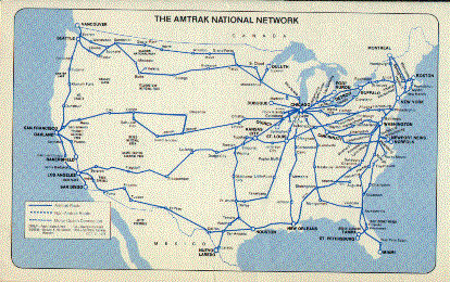


The Sunset Limited takes you from French-accented
New Orleans to vibrant Los Angeles with its proud Spanish heritage.
Our trainglides through the historic,scenic Southwest,over the
pioneer route of the country's second transcontinental railroad.
We traverse pictursquebayous ride through rugged,individualistic
Texas. The Sunset Limited scales mountains,reaching a height of
5,074 feet at Paisano,Texas. We cross rivers and deserts,dipping
to 231 feet below sea level at Salton Sea,California. That's an
altitude variation of almost a mile. Our route takes us through
five states-Louisiana,Texas,New Mexico,Arizona,and California-covering
2,0220miles. Best of all,you see this marvelous Southwest panorama
as it should be seen-at eye level-from your comfortable seat or
from the windows in the cheerful lounge car,which is free to all
passengers. In the pleasant atmosphere of the dining car you can
enjoya choice of excellent full-course meals,along with a variety
of beverages,at moderate cost.
Now let us tell you about the colorful cities,the unique landmarks
and picturesque landscapes along the Sunset Limited route. Eastbound
passengers using this guide should follow their trip by starting
with the back pages and reading foward.
NEW ORLEANS,LA.(Population
569,000-Elevation 5 ft.) Its Creole country,land of the Mardi
Gras,birthplace of Dixieland jazz,a parcel of Old World in the
New,with the famous French Guarter one of the nation's leading
tourist attractions. Founded by Sieur de Bienville,the French
governor,in 1718 and named after the Duke of Orleans, New Orleans
joined the United States in 1803 as part of the Louisiana Purchase,known
around the country as "Jefferson's Folly." Today,the
city is one of the largest ports and distribution centers in the
United States,an important marketing area for cotton, oil, salt,
sulphur, natural gas, agricultural and forest products. It also
boasts a vast new Superdome,adjacent to the station,and Rivergate,a
gigantic convention hall. The New Orleans tourist season starts
with the classic Sugar Bowl college football championship game
on New Year's Day,and is followed by Mardi Gras,a 2-week carnival
in late March or early April. Modern New Orleans, a city of wide
thoroughfares,is lined with tall buildings,surrounded by magnificent
mansions. The Vieux Carre,the famous French Guarter,covers about
70 blocks-a melange of quaint,narrow streets lined with wrought-iron-balconied
houses. Rue Royal is still the main street with fashionable antique
and boutique shops,restaurants and cafes. The French Quarter includes
Beauregard Square,where slaves once danced; the Cabildo,which
was the old Governor's Place;Casa Hove,one of the oldest buildings
in New Orleans;the New Orleans Jazz Museum;and Jackson Square,where
artist congregate just as they do behind Sacre Coeur in Paris.
One of the country's best bargains in sightseeing is a scenic
ride on the St.Charles streetcar line, which passes through some
of the city's most lovely residential areas. New Orleans streetcars,built
in 1923-24,are the oldest cars operating in regular service in
the United States and Canada,and have been immaculately maintained
over the years. Ten miles west of New Orleans,our train crosses
the mighty Mississippi via the Huey P. Long Bridge. Including
approaches,the bridge is 4.4 miles long and extends 3,524 feet
across the river. After crossing the bridge you will see native
flora characteristic of the bayou and lowland area,including bald
cypress trees,water hyacinths and moss. Des Allemands,33 miles
west of New Orleans,
is a quaint old settlement founded in colonial days. The community
is situated on the banks of Des Allemands Bayou,whose waters empty
into Barataria Bay,an inlet of the Gulf of Mexico,one-time haunt
of Jean Lafitte and his pirate crew.
SCHRIEVER,LA.(Pop.650-El.17
ft.) Site of the Terre-Bonne Farms,a resettlement project established
in 1938 by the Farm Security Administration. Beyond Schriever,
the train passes the Chacahoula Swamp. This area,abounding with
fur-bearing animals,is a popular resort for trappers. Just before
reaching New Ibera,the railroad follows the high south bank of
Bayou Teche through thick cane fields and small woodlands. Bayou
Teche is the locale for much Teche-country literature,including
Longfellow's "Evangeline."
NEW IBERIA,LA. (Pop.31,200-El.19
ft.) is known locally as "the sugar bowl." Sugar mills
dot the skyline around Lafourche where,from your train window,you
will catch glimpses through the magnolia trees of the planter's
homes,all built to face the bayous,which were the only highways
before the advent of the railroad. Approximately ten miles south
of New Iberia is Avery Island,site of Edward Avery Mcllhenny's
famous bird sanctuary and home of the renowned Tabasco Sauce factory.
Between LAFAYETTE(Pop.68,908-El.40 ft.) and LAKE CHARLES,LA.(Pop.7,998-El.40
ft.),our train passes through a succession of rice fields,and
you will see many mills at Crowley. You are approaching oil country
and in the distance you can see the derricks of the Welsh oil
field. McNeese State College is located in Lake Charles. West
of the city,our train crosses the Calcasieu River,once a popular
outpost for smugglers when the region between here and the Sabine
River was neutral land,belongine neither to Mexico nor the United
States. Derricks of the Vinton oil fields are visible about a
mile from Sulphur. The train then crosses the Sabine River at
Orange and you are now in Texas,the "Lone Star State."
Orange is located on a deep-water port connected with the Gulf
of Mexico by the Sabine-Neches Waterway. Pirate Jean Lafitte terrorized
the nearby swamps and bayous.
BEAUMONT,TEX.(Pop.115,716-El.22
ft.) is where the first of the Texas wells was to gush with happy
news:OIL! Spindletop Monument now marks the site of the Lucas
Gusher. Your train crosses the Neches River to enter Beaumont,seat
of Jefferson County. Situated on a deep-water channel,Beaumont
is a shipping center supplying materialsto major cities
in the North,East and West. There is also a major ship and barge
building industry here,and Beaumont,together with the surrounding
communities,forms the largest concentration of oil refineries
in the country. The Babe Zaharias Golf Tournament is held annually.
Your route from Beaumont to Huston passes through som e of the
country's most important oil fields. At Dayton,the derricks of
the North Dayton oil fields may be seen from your train. And further
west,you can see the Esperson oil fields to the south.
HOUSTON,TEX.(Pop. 958,491-El.47
ft.),fastest growing metropoliant center in the United States,is
now known for NASA's Lyndon B. Johnson Space Center at Clear Lake.
It's difficult to remember that city's first claim to fame was
cotton. Named for Sam Houston,hero of the Battle of San Jacinto
in which Texas won its independancefrom Mexico,Houston
became the state's first capital city. Much of Houston's pre-space-age
growth can be attributed to the building of the Houston Ship Channel,turning
a city that is situated 50 miles inland from the coast into a
major seaport. And just to add to the city's wealth,the Gulf Coast
heaped oil upon the landowners. But don't think that the ranchers
have been replaced. Mechanization has invaded the prairie but
the area around Houston retains a touch of the spirit and character
of the early Southwest. The city has eight institutions if higher
learning;is a medical,teaching,research and treatment center,and
a music center featuring symphony,opera,jazz,and ballet. And Houston
is the home of the famous Astrodome and Astroworld. West of Houston,we
pass through Sugarland where a sugarcane factory may be seen from
the train. The derricks of the De Walt oil field at Columbus are
closeby. The Colorado River curves about the city like a hoeseshoe
and flows under your train just east of the town.
SAN ANTONIO,TEX. (Pop.
654,153-El.650 ft.)is best known for the Alamo. The Spanish conquistadores
were the first to come to San Antonio,followed by the Mexicans.
It's one of the prettiest American cities with adobe houses and
modern skyscrapers creating curious contrast. This is where Teddy
Roosevelt's Rough Riders were assembled. And it's where Davy
Crockett and Jim Bowie died. The Paseo del Rio (River Walk) is
still the place where couples stroll hand in hand; it's a tree-lined
river promenade,alive with tropical foliage, lined with shops,restuarants
and night spots. As your train leaves San Antonio,you will pass
through the villages of Lacoste,Noonan and Dunlay to Hondo,where
the old Comanche Indian villages
were once located. Further west,the Sunset Limited crosses the
Nueces River where pecans grow along the banks.
DEL RIO,TEX. (Pop 21,330-El.948
ft.)might well be called the "water works" of America's
second largest state. More than 70 million gallons of water flow
daily from San Felipe Springs. The water is for irrigation as
well as domestic use. Del Rio is one of the world's largest shipping
points for wool and mohair. This is the home of the original blue
jeans. Laughlin Air Force Base is just a few miles away. Fourteen
miles west of Del Rio,your train crosses Devil's River,one of
the clearest streams in the world. Below the bridge you can see
Amistad (Friendship) Dam,a jointproject of the United States and
Mexico which has harnessed over 5 million acer-feet of water-more
than one-trillion gallons of water when full. As your train
proceeds west from Del Rio,the scenery will change. The climate
is drier. There are few trees,and sagebrush and similar cactus-like
flora dot the countryside. This is sheep and goat grazing land.
About 50 miles west of Del Rio,the Sunset Limited crosses the
Pecos River High Bridge,321 feet above the water,which flows through
a deep canyon below. Two-and-a-half
miles west of the Pecos River,we pass a point where the last railroad
spike on this line was driven. Fifteen miles west of the Pecos
River High Bridge our train passes through Langtry, a small trading
and shipping community,famous as headquarters for "Judge"
Roy Bean. "Judge" Bean dispensed liqour and supplies
and acted as the "Law West of Pecos"during the frontier
days
when no legitimate law courts existed in this area. He changed
the name of the settlement from Vinegarroon to Langtry in honor
of the actress Lillie Langtry,and had high expectations that she
would visit the place. Some years later,on her way east,she stopped
over to inspect her namesake;meanwhile,the autocratic old judge
had died.
SANDERSON,TEX.(Pop.1,229-El.2,775
ft.)is a shipping center for wool and mohair,and has both an oil
and gas refinery and an agriculture industry. Sanderson is a goat
country,but even the sheep roam free. In the region southwest
of Sanderson and south of Alpine the Rio Grande flows south to
Big Bend countrywhich once harbored outlaws who smuggled cattle
across the river. The Lipan-Apache Indinas lived here. One of
the most remarkable plants to grow in this area is the resurrection
plant,which,when dry,rolls itself into a ball and,when wet,stretches
out into a mass of fernlike fronds. Many of these plants are sold
as curiosity souvenirs. Flourishing here, too, is the peyote,
a small, low, radish-shaped cactus whose greenish berry-called
"white wiskey"-was chewed by the indians for its mildly
intoxicating effect.
EL PASO,TEX.(POP.322,261-EL.3,719
FT.) is a principal gateway toold Mexico and adjacent to its sister
city Ciudad Juarez,Mexico. El Paso means "passage."
The city is truly bilingual with signs, sounds and street names
in Spanish and in English. El Paso's endless summer makes it a
popular winter resort. It's the scene of the Sun Carnival during
the last week of the year,culminating in the annual Sun Bowl football
game,the Sun Carnival basketball game and,of course,the crowning
of the Sun Carnival Queen.Ft.Bliss,the U.S. Army Air Defense Center,is
at the northeast edge of the city and missile firings may be viewed
by visitors. The Ft. Bliss Museum contains U.S. Calvary and early
infantry exhibits,showing how the west was won,or at least how
the routes to the West where surveyed. Excellent views of the
city maybe had from the Aerial Tramway,a 5,622-ft.ride to the
top of Mount Franklin's Rangers Peak. El Paso is home of the University
of Texas,and is Amtrak's
gateway to Carlsbad Caverns National Park. Just outside of El
Paso,our train crosses the Rio Grande,entering New Mexico.
DEMING,N.MEX. (Pop.8,343-El.4,330
ft.) is rock country where agate,jasper and carnelian attract
the serious miners. This is the rich cattle and farming area of
the Mimbers Valley. Cotton,feed grain and livestock are the principal
products. Thirty-two miles west of Deming,our train crosses the
Continental Divide separating the Atlantic and Pacific watersheds
at an elevation of 4,587 ft. This is the lowest railroad crossing
of the Continental Divide in the United States.
LORDSBURG,N.MEX.(Pop.3,429-El.4,249
ft.) is a mining town in Hidalgo County where green patches of
farmland vie with copper and silver mines for their share of territory.
To the south you can see the Pyramid Mountains,rich with silver,copper,
and gold deposits. Seventy miles north at Morenci are extensive
Phelps Dodge copper mines. As our train crosses the border into
Arizona,it becomes obvious that we have entered wild country;
even the mountain peaks have more rugged quality. On the crest
of Chiricahua Mountain near San Simon,you can see a remarkable
rock formation,called
"Cochise Head" because of its unmistakable likeness
to the fierce Apache chief. Countinuing on six miles west of Willcox,we
pass the dry bed of an ancient lake famous for mirages under the
right atmospheric conditions. Frequently,passengers get the feeling
that the train is rolling along near a body of water.
TUCSON,ARIZ. (Pop. 262,483-El.
2,375 ft.) is one of America's favorite health spas. The reason
is summed up in sunshine...lots of it,all the year round. Tucson,surrounded
by mountains, has grown with the tourist in mind. The city offers
modern hotels,dude ranches,lodges,and camping grounds. The largest
industry is the Hughes Air Craft Company,the city's major employer.
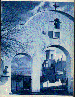
Tucson, on the banks of the Santa Cruz River,is one of the West's
oldest Spanish settlements. It was founded in 1692 by a Jesuit
priest,and it retains its Spanish character even as it grows modern.
In 1776, Mexicans sought refuge in the Indian village protected
by adobe walls. Back in 1880 when the Apaches were still on the
warpath here,the ols Pueblo's 2,000 inhabitants greeted the track
builders as they reached Tucson with a 38-gun salute and a calvary
band playing a medley of patriotic songs. As the construction
crews continued east from Tucson,they were protected by military
escort. The
University of Arizona is in Tucson and the Cleveland Indians have
their winter training here. Papago Indian Reservation is nearby.
Tucson Mountain Park,covering more than 30,000 acres of natural
desert growth,is a state game preserve. Between Tucson and Phoenix,just
seven miles west of Red Rock,your train passes Picacho Peak,a
large butte to the south rising abruptly from the desert floor.
Beginning here and continuing west for five miles,one of the finest
naturalk cactus gardens in Arizona,the Picacho Peak Sahuaro Forest,extends
along the south side of the track. And seven miles further west,a
stone monument just south of the railroad tracks marks the scene
of the only battle fought in Arizona between Union and Confederate
forces during the Cival War.
PHOENIX,ARIZ.(Pop.581,562-El.1,084
ft.) Fertile fields in a desert land-an oasis-as much a sign of
immortality as the bird after whom it is named. It was the prehistoric
Indians who first settled in Phoenix and brought their ingenious
irrigation methods with them. The Hohokam Indians were farmers
and "artist" who etched canals into the arid earth and
brought life to the desert sands. They came. They flourished.
They dissapeared,like the symbolic Egyptian phoenix which consumes
itself every 500 years and than rises from its own ashes. The
first white settlers arrived in 1860,attracted by the Indian canals,
and a civilization was reborn just as Egyptian myth predicted.
Phoenix,Arizona's capital city,is near the Roosevelt Dam which
has made the fields fertile-ripe over olives,citrus fruits and
dates. When Arizona became the 48th state in 1912,the State Capitol
was erected out of native stones. The State's Museum,housed in
the Capitol Building,contains exhibits of prehistoric Indian cultures,modern
Inidan
crafts and historical documents. Frank Lloyd Wright left his strongest
imprint here;you'll see it in the uninhibited architecture around
the city.
YUMA,ARIZ.(Pop.29,007-El.147ft.)
is named for the Yuma Indians whi inhabited the area before thw
white man's arrival. The sand dunes west of Yuma are probably
the most photographed in the world; Hollywood shoots deserts scenes
here. The dunes may be seen from your train after we cross the
Colorado River. Franisco Garces,who founded two missions in Yuma,was
massacred along with the colonist during the last Yuma Indian
uprising in 1781. His statue stands in the gardens of the Catholic
Indian Mission,erected on the site of the massacre. The Fort Yuma
Indian Reservation is on the west bank of the Colorado River.
To the north,at the edge of the river,is the Old Territorial Prison
of the frontier days. The All-American Canal near Yuma irrigates
much of the California's Imperial and Coachella Valleys. Today,the
city is a popular winter resort with fishing and boating on the
Colorado River,which serves as the border between Arizona and
California.
The time changes from Mountain to Pacific time here,so set your
watch bach one hour going west...ahead one hour going east.
PAMONA,CALIF.(Pop.87,383-El.855
ft.),named after the Roman goddess of fruit,gets its fame from
the Los Angeles County Fair held here mid-September to early October.
More than a million visitors come to Pamona each year for the
festivities. Oranges and lemons are Pamona's principal productsl.
Arabian horses are raised and trained at the Kellogg Campus of
California State Polytechnic College,where Arabian Horse Shows
are held throughout the year. At Padua Hills Theatre, Mexican
actors. Mount Baldy,a winter skiing and recreational area,is located
15 miles north of here.
LOS ANGELES,CALIF.(Pop.2,816,061-El.297
ft.) is not a city in the conventional sense. Los Angeles is Hollywood,Beverly
Hills,Burbank,Culver City,Glendale,Inglewood,Pasadena,Santa Monica
and Malibu. It was founded
in 1781 by Felipe de Neve as the "Village of our Lady,Queen
of the Angles" was the last town to surrender to the United
States in 1847. Los Angeles is movieland,and although the great
Hollywood days may be over, still more than two-thirds of the
world's motion pictures are produced here. Los Angeles' earliest
growth was largely due to the citrus industry. It is now an oil-refinery
center and the city has attracted both light and heavy industry.
Great views of the citymay be seen from the top of the Civic Center.
Most frequently visited by California tourist are the famed Farmer's
Market,the movie and television studios,red-bricked Olver Street
(oldest in the city),the world-famous Hollywood Bowl and nearby
Disneyland. Our train arrives in spacious and attractive Los Angeles
Union PassengerTerminal. This handsome station,designed in the
traditional Californis mission style,was built in 1939. It replaced
two separate terminals operated by the Union Pacific,Southern
Pacific and Santa Fe Railroads. The distinctive architecture of
the impressive building incorporates modern passenger facilities.
the station is across from picturesque Olvera Street and the Publo
de Los Angeles restoration area,on the orignal site of the city.
Adjacent to downtown and goverment offices, the terminal is a
convenient arrival and departure point for Amtrak passengers.
If you have come from New Orleans to Los Angeles with us,you've
experianced over 2,000 miles of train travel at its best. We hope
you found our "resturant on wheels" and lounge service
enjoyable. And if you traveled in the privacy of a roomette or
bedroom,we trust that your accommodations were both pleasant and
comfortable. We hope that enjoyed you stay on the Sunset Limited.
If you have any questions about connecting service or any other
services Amtrak offers,take advantage of our nationwide intercity
reservations network. Simply call one of the numbers listed below.